
Whether I am doing my own family research or tracing the lineage of a woman applying for membership in DAR, I cannot help noticing the names of places people were from. It seems more often than not towns were named after people who settled there.
Here in Virginia, the names of early settlers are still attached to communities in the Shenandoah Valley: Rileyville, Comertown, Mayland, Cubbage Hollow, Lucas Hollow, Shiflett Hollow, Buracker Hollow, Jewell Hollow, Hensley Hollow, Simmers Hollow, Eaton Hollow, Weaver Hollow, Wise Hollow, and – wait for it – Jollett Hollow.
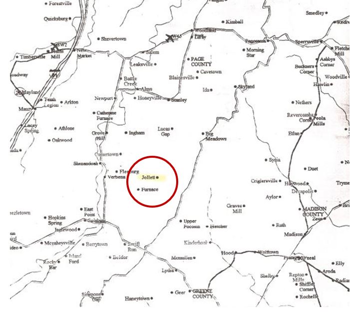
So how did the area get the name “Jollett Hollow”?
My 3X great-grandfather Fielding Jollett was the first of the Jolletts to settle in the narrow valley that later became “Jollett Hollow.” He married Anne Stoutemire 7 December 1822 in Rockingham County, just across the mountain from his birthplace in Greene County. Two years later, he purchased 2 acres that bordered land owned presumably by his in-laws.
 |
| Rockingham County Deed Book B p 176 |
He amassed more land over time. In 1859 he deeded 200 acres to his son James Franklin Jollett (my 2X great-grandfather) and 37 acres to his other son John Wesley Jollett. Both were farmers like their father. The enterprising John Wesley also was a preacher and owner of a general store.
A book published in 1952 called A Short History of Page County claims that there was no post office at Jollett, but records of the Post Office Department prove otherwise. In 1888, an application was filed to locate a post office in Shenandoah Iron Works District “7 miles east of the South Fork of the Shenandoah River on the north bank of Naked Creek 3 miles east of Furnace and 10 miles south of Marksville.” John Wesley Jollett applied to be the post master and operated the post office out of his store.
 |
| from US Appointments of Postmasters 1832-1971 |
The best explanation for how the community got its name can thus be traced to the decision to locate a post office in Reverend Jollett’s store.
Jollett’s Post Office was just one of the things bearing my ancestors’ name. There was the Jollett School or Jollett’s Schoolhouse, the Jollett Chapel, a Methodist Episcopal Church, and the Jollett Cemetery, all on land provided by John Wesley Jollett.

The 1885 Lake Atlas of Shenandoah Iron Works District shows 2 schools near the “M E Church.” I have no explanation for that and furthermore have no idea which one was the Jollett School. The schools are long gone but the church and the cemetery are still in use.
 |
| Jollett Methodist Church as it looks today |
The land that John Wesley gave for the use of the church was from a tract he purchased from his wife’s family in 1866. The land was once owned by Sarah Elizabeth’s great-grandfather, Revolutionary War veteran Jacob Smith and his wife Winna (Winifred). Upon their deaths, the land was inherited by their youngest son, Gabriel. With $100 down and a promise of 3 more cash payments of $200 each, John Wesley purchased what appears to be connecting properties, one about 180 acres and another about 214. The description of the property boundary going along a “high hill” matches the lay of the land of the cemetery.
. . . the said above named parties of the first part have this day sold & do hereby grant & convey unto the said John W. Jollett, a certain tract or parcel of land of which Gabriel Smith died possessed, lying & being on North Naked Creek in the County of Page & State of Virginia & adjoining & bounded by the lands of Reuben Epard, Montella Utz, & John Weaver, containing by estimation One hundred and eighty acres more or less & bounded as follows to wit, Beginning at a large white pine tree, standing on a South hill side, corner to Reuben Epard, Thence with his lines N. 2 ¾ E. 31 2/10 poles to a pile of rock near a __ tree standing near the mansion house thence N. 21_ E. 23 6/10 poles to an oak planted thence N. 60 W. 54 [?] poles to a black oak tree standing in a hollow near a drain, thence N. 20º E. [17? 18?] 19 poles to the gum saplings, corner to said Epard and in Montello Utz’s line thence with his lines N. 30º E. 60 poles, to a double dogwood standing on a hill thence N. 48 ½, E. 46 poles to a gum tree standing at the base of a hill and near the creek, thence N. 37º E. 74 poles to the large black oak, thence S. 79 E. 166 poles to two large black oak trees, one fallen, and on the top of a high hill, corner to __ Epard, Montello Utz, and John Weaver, thence with Weaver’s line S. 27 ½ W. 126 poles to two blown down trees and a white oak standing, corner to Reuben Epard, thence with his line S. 58 ½ W. 196 poles to the beginning, containing two hundred and fourteen acres more or less.
 |
| The drive up the "high hill" - steeper than it looks (See the cemetery just above the white barn.) |
 |
| Closer view of the cemetery |
 |
| Jollett Cemetery |
The Jolletts can’t claim any great inventions or discoveries, but they got their name on the map just the same.

Amy Johnson Crow continues to challenge genealogy bloggers and non-bloggers alike to think about our ancestors and share a story or photo about them. The challenge is “52 Ancestors in 52 Weeks.”
Wendy
© 2020, Wendy Mathias. All rights reserved.
Wow, you're on the map! Interesting that he deeded 200 acres to James and only 37 acres to John. Wonder what that was about?
ReplyDeleteThat is a beautiful view in the cemetery. A nice place to be laid to rest. How cool to have a hollow named for your family!
ReplyDeleteBetty
I thoroughly enjoyed the blog. The photos are fantastic and the cemetery looks so peaceful.
ReplyDeleteYou inspire me to take a closer look for places and things bearing my ancestor's names. Excellent research!
ReplyDeleteFantastic! What fun to find your name on the map, and connect it to your family. Thanks for sharing.
ReplyDeleteI have just found your blog and look forward to reading the previous years' entries. My husband's grandfather, Abraham Israel Burner, lived in Overall on the banks of the Shenandoah. (His "Switzer" barn was moved to the outdoor museum across the road from Luray Caverns. Many of his ancestors are buried either in a tiny cemetery on the land there or in the Rileyville Cemetery. We love driving around the area (we live in No. VA) and visiting Burner relatives in Luray.
ReplyDelete